New Jersey Future Blog
Web Mapping to Support Smart Equitable Cities in Community Planning
June 25th, 2021 by Andrew Tabas

“Web mapping is a supertool for planners,” according to Rowan University Geography Professor John Hasse. The Web Mapping to Support Smart Equitable Cities in Community Planning session at the 2021 New Jersey Planning and Redevelopment Conference demonstrated just that with several case studies highlighting new web mapping initiatives in New Jersey. In addition to Hasse, the panelists included South Jersey Land & Water Trust Executive Director Christine Nolan; Rowan University Assistant Professor of Planning Mahbubur Meenar; New Jersey Conservation Foundation GIS Manager Tanya Nolte; New Jersey Department of Environmental Protection Deputy Commissioner, Environmental Justice & Equity Olivia Glenn; and New Jersey Future Policy and Program Coordinator Andrew Tabas. These organizations and others are turning to web mapping to promote more equitable community planning.
Web mapping is the use of Geographic Information Systems to display information in an online map. Unlike other types of maps, web maps are interactive. Users can turn layers on and off, zoom in and out, and click popups to find information. For more information on web mapping, read the Web Mapping 101 post by Esri.
Equity should be at the forefront of community planning, according to Meenar. He explained that equality provides everyone with the same resources, while equity provides everyone with the resources necessary for their success. Figure 1 illustrates this idea. As Meenar explained—and subsequent case studies showed—equity mapping is important, because it enables comparisons of different indicators in different areas.
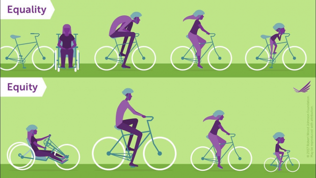
Figure 1: Equality vs. equity. Source: Robert Wood Johnson Foundation.
Putting web mapping into practice, Hasse and Nolte presented a Rowan University web mapping project called NJ Map, which is designed to advance equity in community planning. The site has a variety of maps on various topics related to environmental protection, land use, and water quality. One of the maps housed within NJ Map is the Camden Conservation Blueprint, which shows the locations of parks in Camden. The map includes several layers to examine equitable access to parks. For example, as shown in Figure 2, users can view a visual representation of the acres of parkland within walking distance of Camden’s neighborhoods. Camden Conservation Blueprint was prepared with community input. For example, community members suggested the addition of a new layer to show park amenities. Involving community members in the mapmaking process can lead to a more useful final product, according to Nolte and Hasse.
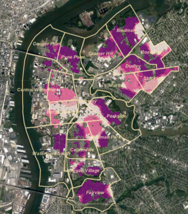
Figure 2: Acres of parkland within walking distance of homes in Camden, NJ. Source: Camden Conservation Blueprint.
The New Jersey Department of Environmental Protection (NJDEP) is also committed to using maps to advance equity and environmental justice in New Jersey. Glenn explained that environmental justice entails “the fair treatment and meaningful involvement of all people regardless of race, color, national origin, or income with respect to the development, implementation, and enforcement of environmental laws, regulations, and policies.” To advance environmental justice, NJDEP has defined and mapped “overburdened communities” across the state (see Figure 3). Through the new Environmental Justice Law, these communities can respond to the cumulative impacts of pollution more effectively. NJDEP has developed an Environmental Justice Mapping Tool to display detailed information about these communities.
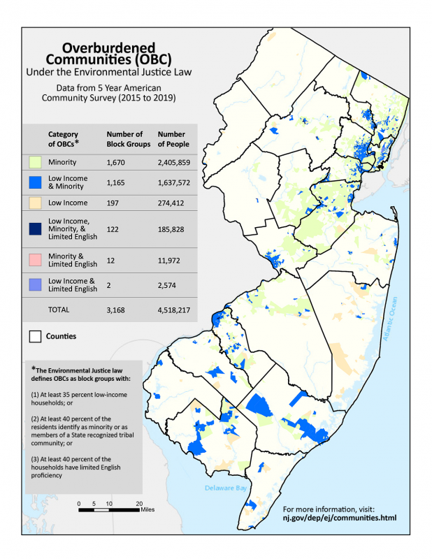
Figure 3: NJDEP’s map of “overburdened communities” in New Jersey. Source: NJDEP.
One of the most exciting parts about NJDEP’s efforts, from a mapping perspective, is that NJDEP has made its “overburdened communities” layer publicly accessible. New Jersey Future and Jersey Water Works are making use of this layer in the New Jersey Water Risk and Equity Map, a project to explore the intersections between flood risk, water quality, and demographics. To learn more about this mapping effort, register for the Jersey Water Works Membership Meeting in July.
Web mapping can bring together geography, data analysis, planning, and environmental policy to demonstrate the need for a more equitable future. Grab your computer and start to explore the information that is available about your community!
Related Posts
 June 25, 2021 Filling the Missing Middle: Context-Sensitive Design and Development Innovations for Diverse, Sustainable, Walkable Neighborhoods
 June 25, 2021 Oh, Sweet Relief! Stormwater Utilities as an Equitable Tool to Solve Flooding and Pollution
 June 25, 2021 Savvy Stormwater Strategies: How Planning at Every Level Can Help New Jersey Weather the Storm
 June 25, 2021 Ensuring Equity in Transit-Oriented Development
 June 25, 2021 Municipal Approach to Racial and Economic Inclusion
Tags: NJPRC21, Planning and Redevelopment Conference, We mapping


