New Jersey Future Blog
Where does impervious cover have the biggest impact?
November 11th, 2019 by Tim Evans
Impervious cover, surfaces such as roads and rooftops that are impenetrable to water, has economic and environmental impacts on municipalities. Streets and sidewalks are expensive to maintain and these surfaces generate stormwater runoff which causes flooding and carries polluted water into our streams and rivers.
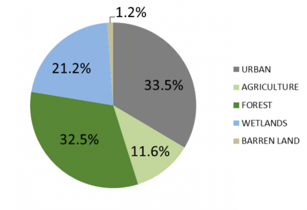
The New Jersey Department of Environmental Protection (DEP) recently released a 2015 update of its land use / land cover data set. The LU/LC dataset offers a periodic snapshot of how and where New Jersey both uses and preserves its land. For example, a little over one-third (33.5 percent) of the state’s land is urbanized and a little less than another third (32.5 percent) is forest, with another 11.6 percent in agricultural use and 21.2 percent in wetlands (and the small remainder classified as “barren land,” a catch-all category that includes things like beaches, quarries, and land that has been cleared for development but on which nothing has yet been built).
One feature of interest is the data set’s inclusion of an estimate of impervious surface – things like roads and rooftops that are impervious to water and hence generate stormwater runoff when it rains, rather than allowing water to soak into the ground. From the data provided for smaller plots of land, it is possible to produce summaries that show how much impervious surface in the state is due to which specific land-use categories. These summaries in turn illustrate an important, though perhaps counterintuitive, point about the environmental benefits of density.
Five of the 24 subcategories in the “urban” category of land use pertain to residential development of various types and are described as follows in the metadata:
- Residential (High Density or Multiple Dwelling): This category contains either high-density single units or multiple dwelling units on 1/8 to 1/5-acre lots. These areas are commonly found in the densely populated urban zones.
- Residential (Single Unit, Medium Density): This category is made up of residential urban/suburban neighborhoods greater than 1/8 acre and up to and including ½ acre lots.
- Residential (Single Unit, Low Density): This category contains single unit residential neighborhoods with areas greater than ½ acre up to and including 1 acre lots.
- Residential (Rural, Single Unit): This category contains single unit residential neighborhoods with lots that are at least one acre or larger. This type is typically found in sparsely populated regions surrounded by or adjacent to forested or agricultural lands. Also included are estates or modern sub-divisions with large lot sizes providing a density less than or equal to one dwelling unit per acre.
- Mixed Residential: The mixed residential category is used for an area where various residential uses occur and the individual uses cannot be separated at mapping scale (1 acre). Where more than 1/3 intermixture of other residential use or uses occurs in a specific area, it is classified as mixed residential. Where the inter-mixtures of other residential land use or uses total less than 1/3 of the specified area, the dominant land use category is applied.
By summing the total acreage and the impervious acreage for all pieces of land in the database within each of these five subcategories, we can construct estimates of the total amount of New Jersey’s land that is devoted to each of these uses, and what percent of each subcategory’s land is impervious surface:
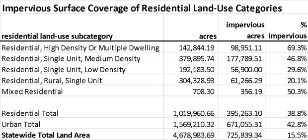
Note that residential development overall devotes 38.8 percent of its acreage to impervious surfaces, on average. Residential development thus produces slightly less impervious surface per acre than urban land more generally, because other types of urban uses – especially commercial and industrial properties – tend to build out a much higher percent of their lots with buildings and pavement (especially parking lots) and don’t tend to have much in the way of green space. (A little more than 15 percent of the state’s land area is covered by impervious surfaces overall.)
Lawns and wooded areas account for the main difference in impervious surface percent between residential development on one hand and other urban uses on the other. But they also account for differences among the different subcategories of residential development. Note that among the residential subcategories, the type that generates the most impervious coverage per acre is the highest density category; properties in this category, which tend to be found in the more densely populated urban areas in the state where lawns are both smaller and less common, typically have about 70 percent of their area covered by impervious surfaces. Even medium-density suburban neighborhoods, with 2 to 8 housing units per acre, devote nearly half (46.8 percent) of their land to impervious surfaces. In contrast, residential development in rural areas that is dominated by single-family detached homes on large lots (1 acre or more) only devotes an average of 20 percent of its total land area to driveways, roofs, and other impervious surfaces. It may thus appear that the most environmentally-friendly residential form, from the standpoint of generating stormwater runoff, is low-density subdivisions with big lawns and/or lots of trees.
But per acre is the wrong denominator to use in measuring residential development’s effect on impervious surface. When we talk about the future growth of a state, what we are talking about is how many new people or households the state expects to gain over a given time period. States seek to attract new residents, not new urbanized acreage. The number of new acres a state must develop is a function of how many new people move in, not the other way around. But the number of newly developed acres is also a function of how we choose to accommodate new population growth. Will most of it be accommodated via large-lot, single-family development, or via higher-density neighborhoods with apartments, townhouses, and single-family homes on smaller lots? The types of housing that new residents move into can have widely varying effects on how much new impervious surface gets added per new resident.
To keep the math simple, let’s consider a time frame over which New Jersey expects to have to supply 100,000 additional housing units. As of the 2018 American Community Survey, the average household size – that is, the number of people per occupied housing unit – in New Jersey is 2.69 people. Using this average, 100,000 new housing units translates to roughly 269,000 new people. This is about equivalent to the amount of population growth that has occurred in New Jersey from 2004 to 2018, a 14-year time frame. We are thus roughly considering how many new acres of impervious surface we can expect to be generated by about 14 years’ worth of population growth under different residential development scenarios.
For each of the four residential land-use categories for which the description specifies a density range, let us pick a representative value for number of units per acre: 10 units per acre for the densest category (this is actually quite a conservative estimate; neighborhoods dominated by rowhouses and apartments will have many more units per acre than 10), 5 units per acre for the medium-density category (which spans from 2 to 8 units per acre), 1.5 units per acre for low-density (lot sizes of between ½ and 1 acre), and 0.5 units per acre for suburban estate developments and rural areas (this corresponds to 2-acre lots; average lot sizes can of course be much larger than this in such developments). The table below shows what each of these development densities translates to, in terms of number of newly developed acres and thence new acreage of impervious surface.

Using the average impervious surface coverage rates of the different residential development types, we can see that when measured on a per-capita or per-household basis, rural single-family development produces by far the largest number of new acres of impervious surface for a given population increase; an additional 100,000 households will create 40,000 additional impervious acres. The highest-density housing types, in contrast, result in the least amount of new impervious surface – less than 7,000 new impervious acres for the same increase of 100,000 households. The tendency of higher-density housing types to cover more of their land area with impervious surfaces is more than made up for by the fact that higher density housing consumes far less acreage per person.
If the goal of more environmentally conscious development is to minimize the increase in impervious surface coverage (and thence stormwater runoff) that will be created by a given increase in population size, then, the best way to achieve this is by accommodating as much of the population increase in high-density, rather than low-density, housing types. Similarly, the cost to maintain roads and sidewalks in dense cities is distributed among more people, making dense development a more economic alternative to sprawling communities.
Related Posts
 February 20, 2007 Redevelopment on the Rise
 May 21, 2004 Rethinking Oil Consumption
 July 8, 2022 Equitable, Sustainable Development and Redevelopment for a Bright New Jersey Future
 May 16, 2018 Green Infrastructure Draws Attention at Atlantic Builders Convention
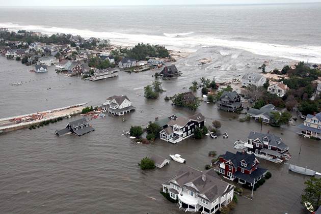 March 11, 2014 Draft 2014 New Jersey Hazard Mitigation Plan Available for Comment


