New Jersey Future Blog
Regional Planning in the Pinelands: Well-Directed Growth, but What Effect on Natural Resources?
April 11th, 2013 by Tim Evans
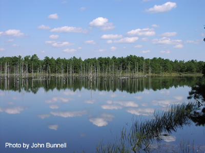
Stafford Forge, Ocean County. Source: New Jersey Pinelands Commission
New Jersey has a long and proud history of regional planning. Perhaps the crown jewel in this history is the landmark 1979 Pinelands Protection Act, which established a regional plan (the Pinelands Comprehensive Management Plan, or CMP) and governance structure (the Pinelands Commission) restricting development in environmentally sensitive areas in order to preserve natural and cultural resources for millions of New Jerseyans in the southern half of the state. Underlying the CMP is the principle that future growth should be directed into locations that already have the infrastructure in place to support development, or where such infrastructure can most efficiently be extended while minimizing the effects on the environment.
The Pinelands CMP seeks to channel growth into certain locations, not to stop growth altogether. In the Pinelands CMP there are three primary types of growth areas: Pinelands Towns, Pinelands Villages, and Regional Growth Areas. The first two types are generally pre-existing stand-alone centers surrounded by natural or agricultural lands, while the third category consists of lands near the edge of the “Pinelands Area” (the area designated by the Pinelands Protection Act as being under the exclusive jurisdiction of the Pinelands Commission) that are adjacent to already-developed and largely suburban areas just outside the Pinelands boundary.
How well have these designations succeeded at steering growth away from critical agricultural and water recharge lands? Have they done so without acting as an undue drag on overall growth? And what effect has overall growth had on natural resources in these areas?
Pinelands Effort Succeeds in Steering Growth
On the first question, we can turn to Tracking New Jersey’s Dynamic Landscape: Urban Growth and Open Space Loss 1986-1995‐2002 (pdf), a report prepared by land-use researchers at Rowan and Rutgers universities. Section 4.2 of the report, beginning on p. 46, looks at land development in the Pinelands Area and assesses whether the CMP has been effective at preserving open lands and steering growth into designated growth areas. The report finds positive results on both counts:
In 1995, the Pinelands contained 25.8% of the land available for development in the state. However, during (the period from 1995 to 2002) it experienced only 7.5% of the state’s (land) development growth. In contrast, areas outside the Pinelands Zone developed 92.5% of the state’s growth (over the same period), even though it contained only 74.2% of the state’s available land. The overall pace of urbanization gauged against the proportion of available land demonstrates that the magnitude of (land) development was considerably slower inside than outside of the Pinelands.
And:
More significant than controlling the magnitude of urbanization in the Pinelands, the findings demonstrate that the Pinelands CMP has functioned well at channeling the development into the designated growth areas.
…
A substantially higher proportion of development occurred in the designated areas, which include the Regional Growth, Towns, Villages, and Rural Development areas, when compared to the more protected Preservation, Special Agricultural and Forest areas which receive far less development.
On the second question – has steering population growth into specific growth areas while restricting it in the preservation areas resulted in overall growth being suppressed? – the answer, perhaps surprisingly, appears to be no.
The Pinelands Area as defined by the state legislation includes all or part of 53 municipalities. Some municipalities have only a small corner of their land within this area, but there are 46 municipalities with at least 20 percent of their land in the Pinelands and 32 municipalities with at least half their land area covered. Eleven municipalities are entirely within the Pinelands Area.
Regardless of which group of municipalities we consider, the Pinelands Area consistently has grown faster than the state as a whole since 1970, the last decennial Census before the Pinelands CMP was created, as well as over just the 2000-2010 decade. The table below shows New Jersey total statewide growth rates for the 2000-2010 decade and for the entire 40-year period from 1970 to 2010, and then provides growth rates over the same two periods for municipalities with different percentages of Pinelands-governed land.
| Population: | % Population Change: | ||||
|---|---|---|---|---|---|
| 1970 | 2000 | 2010 | 1970-2010 | 2000-2010 | |
| New Jersey total | 7,171,112 | 8,414,350 | 8,791,894 | 22.6% | 4.5% |
| at least partially in the Pinelands (53 munis) | 381,576 | 808,488 | 899,767 | 132.4% | 11.6% |
| at least 20 percent of land area in Pinelands (46 munis) | 259,819 | 610,694 | 692,735 | 166.6% | 13.4% |
| at least 50 percent of land area in Pinelands (32 munis) | 180,710 | 373,042 | 411,642 | 127.8% | 10.3% |
| entirely within PMA (11 munis) | 36,718 | 56,643 | 59,409 | 61.8% | 4.9% |
The municipalities that are partly-inside, partly-outside the Pinelands have clearly been outstripping statewide population growth by substantial margins. But even if we look only at the “heart” of the Pinelands — the 11 municipalities that are entirely contained within the Pinelands Area– we still see them growing slightly faster than the state as a whole over the last decade and nearly three times as fast as the statewide growth rate for the entire 40-year period. It should be noted that all 11 of these municipalities contain at least one Pinelands Growth Area, and all but two of them contain part or all of at least one Pinelands Town or Village, the growth areas that are meant to be centers.
But How Are Growing Areas Affecting Natural Resources?
This overall growth makes the third question – what has been its effect on natural resources? – especially important. Has the fact that the Pinelands area of New Jersey has grown at a fairly rapid rate, and more rapidly than the state overall, resulted in a degradation of its critical water resources?
According to Carleton Montgomery, the executive director of the Pinelands Preservation Alliance, a not-for-profit that advocates for preservation and protection of the Pinelands’ natural resources, there is a lot of data on the impacts of development inside and around the Pinelands on the natural resources the program is designed to protect, but the overall verdict is mixed. The CMP has worked extremely well for watersheds whose headwaters are protected and where impervious cover is very limited throughout the watershed, but in others development is slowly degrading water quality and, in many areas, draining wetlands and streams. In the preservation areas where the forest has largely been kept intact, water is good and plentiful, and native and rare species generally thrive. Where the forest has been fragmented and where wetlands have been compromised, the same is not true.
Says Montgomery: “These basic points should serve as a foundation for the need to continue being vigilant, for continuing to study the effects of the program, and for doing adaptive management where science shows the CMP is not working as intended.”
Note: This post has been updated with information about the Pinelands Preservation Alliance, and also to correct the number of municipalities having at least some of their land area within the Pinelands Area. That number was initially reported as 55 rather than the correct number of 53.
Related Posts
 September 3, 2019 Green infrastructure resource wins national award
 February 24, 2011 Transit-Accessible Towns In New Jersey Are More Recession-Resistant
 June 27, 2011 Democrats’ Proposed Budget Includes Funding for Transit Village Program
 June 30, 2005 Saving Money by Choice
 May 28, 2010 This Week in Land Use


The figures marshalled in this report on the Pinelands give the lie to the development interests who claimed that a conservation-oriented regional planning process would stymie development across the region –if not by adverse decisions then by red-tape, delay and added expense. Future research might apply this lesson to the current, contentious debate about the Highlands. A clear plan and clear standards can smooth the path to development, perhaps even turn that path into a highway.